


Echola Community Center, Tuscaloosa County, Alabama
About
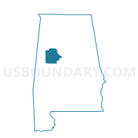
Outline

Summary
| Unique Area Identifier | 523025 |
| Name | Echola Community Center |
| County | Tuscaloosa County |
| State | Alabama |
| Area (square miles) | 96.69 |
| Land Area (square miles) | 95.59 |
| Water Area (square miles) | 1.10 |
| % of Land Area | 98.87 |
| % of Water Area | 1.13 |
| Latitude of the Internal Point | 33.35389470 |
| Longtitude of the Internal Point | -87.79644360 |
Maps


Graphs
Select a template below for downloading or customizing gragh for Echola Community Center, Tuscaloosa County, Alabama


Neighbors
Neighoring Voting District (by Name) Neighboring Voting District on the Map
- Benevola Community Center, Pickens County, AL
- Coker-Buhl-Romulas Masonic Lodge, Tuscaloosa County, AL
- Fairview-Zion Community Center, Pickens County, AL
- Gordo 3 City Hall, Pickens County, AL
- Hico, Fayette County, AL
- Jena Clubhouse, Greene County, AL
- Kirk Fire Dept, Pickens County, AL
- Montgomery Fire Station, Tuscaloosa County, AL
- Mt Olive Fire Station, Tuscaloosa County, AL
Top 10 Neighboring County Subdivision (by Population) Neighboring County Subdivision on the Map
- Northport CCD, Tuscaloosa County, AL (30,007)
- Fayette CCD, Fayette County, AL (8,553)
- Aliceville CCD, Pickens County, AL (5,384)
- Samantha CCD, Tuscaloosa County, AL (5,182)
- Gordo CCD, Pickens County, AL (4,837)
- Coker CCD, Tuscaloosa County, AL (3,721)
- Mantua-West Greene CCD, Greene County, AL (1,814)
- Elrod-Moores Bridge-Echola CCD, Tuscaloosa County, AL (1,545)
Top 10 Neighboring Unified School District (by Population) Neighboring Unified School District on the Map
- Tuscaloosa County School District, AL (105,218)
- Pickens County School District, AL (19,746)
- Fayette County School District, AL (15,936)
- Greene County School District, AL (9,045)
Top 10 Neighboring State Legislative District Lower Chamber (by Population) Neighboring State Legislative District Lower Chamber on the Map
- State House District 61, AL (41,422)
- State House District 16, AL (40,993)
- State House District 14, AL (40,597)
- State House District 71, AL (38,094)
Top 10 Neighboring State Legislative District Upper Chamber (by Population) Neighboring State Legislative District Upper Chamber on the Map
- State Senate District 21, AL (140,682)
- State Senate District 24, AL (118,832)
- State Senate District 6, AL (117,045)
Top 10 Neighboring 111th Congressional District (by Population) Neighboring 111th Congressional District on the Map
- Congressional District 6, AL (754,482)
- Congressional District 4, AL (660,162)
- Congressional District 7, AL (603,352)
Top 10 Neighboring Census Tract (by Population) Neighboring Census Tract on the Map
- Census Tract 101.03, Tuscaloosa County, AL (6,727)
- Census Tract 103.01, Tuscaloosa County, AL (6,324)
- Census Tract 504, Pickens County, AL (5,384)
- Census Tract 500, Pickens County, AL (4,837)
- Census Tract 203, Fayette County, AL (4,054)
- Census Tract 103.02, Tuscaloosa County, AL (3,721)
- Census Tract 600, Greene County, AL (1,814)
Top 10 Neighboring 5-Digit ZIP Code Tabulation Area (by Population) Neighboring 5-Digit ZIP Code Tabulation Area on the Map
- 35475, AL (14,507)
- 35555, AL (10,177)
- 35466, AL (6,075)
- 35452, AL (3,880)
- 35446, AL (2,234)
- 35574, AL (1,507)
- 35480, AL (1,343)
- 35458, AL (594)
- 35457, AL (82)